For American travelers planning road trips, regional exploration, and state-by-state adventures, having a reliable map can make all the difference. The following five products cover traditional road atlases, easy-to-read state maps, a national atlas spanning three countries, a playful states-tracker journal, and a scratch-off USA map that doubles as a decorative keepsake. Each option suits different planning styles—from detailed navigation to interactive tracking—helping you map your next journey with confidence.
| Product | Brand | Format | Notes |
|---|---|---|---|
| Rand McNally Road Atlas Large Scale 2026 | Rand McNally (Author) | Large scale road atlas | USA, Canada, Mexico coverage |
| Rand McNally Easy to Read: United States Map | Rand McNally (Author) | State-focused map | Clear, user-friendly formatting |
| National Geographic Road Atlas 2026: Adventure Edition | National Geographic Maps (Author) | National road atlas | Adventure edition across USA, Canada, Mexico |
| 50 States Tracker & Travel Journal | — | Travel journal & map tracker | Flag stickers; track visited states |
| Detailed Scratch off USA Map with Scratcher | Divalis Store | Scratch-off travel poster | 63 National Parks; landmarks and features |
Rand McNally Road Atlas Large Scale 2026

The Rand McNally Road Atlas Large Scale 2026 provides expansive magnetic-scale detail for motorists traveling the United States, Canada, and Mexico. It is designed for road navigation with large print, clear road networks, city indexes, and pocket-friendly layouts. This atlas is ideal for travelers who prefer a traditional book-style map with comprehensive national coverage and easy-to-read routes for planning cross-border trips.
Rand McNally Easy to Read: United States Map

This map focuses on ease of use and readability, helping travelers locate states, major highways, and regional points of interest with bold labeling and simplified detail. It’s well-suited for quick planning sessions, classroom use, or a compact reference when on the road. The straightforward design helps users avoid information overload during trips.
National Geographic Road Atlas 2026: Adventure Edition

The National Geographic Road Atlas 2026 Adventure Edition bundles authoritative mapping with aspirational exploration. Covering the United States, Canada, and Mexico, this atlas emphasizes scenic routes, national parks, and travel-ready detail for long road trips. It’s a strong pick for travelers who value high-quality cartography, trust the National Geographic brand, and want a guide that supports immersive journeys across multiple countries.
50 States Tracker & Travel Journal

This travel journal doubles as a visual and narrative tracker for state visits. The product provides space to record experiences, plus stickers or markers to flag milestones. It’s a thoughtful gift for families, students, or travelers who enjoy a tactile, keepsake-style record of their U.S. journeys, combining memory-keeping with a practical map-like layout.
Detailed Scratch off USA Map with Scratcher
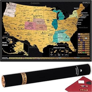
From the Divalis Store, this scratch-off map offers an interactive way to track U.S. travel highlights. The kit includes a scraper, coating, and accessories for easy scratch-off progress. It highlights 63 national parks, top U.S. peaks, rivers, cities, and more, blending a decorative element with an informative index for a visually engaging planning and memory-keeping tool.
Buying Guide: Key Purchase Considerations
- Coverage and scope: Decide whether you want nationwide, cross-border (USA-Canada-MMexico), or state-focused maps. The Rand McNally large-scale atlas covers three countries, while the Rand McNally Easy to Read map and National Geographic atlas emphasize the United States with accessible detail.
- Format and usability: Large-scale road atlases suit detailed planning and offline use on trips, whereas a scratch-off map or a travel journal offers interactive and decorative value for ongoing motivation and memory-keeping.
- Detail versus readability: If you travel frequently and need precise routing, larger formats with clear road networks are beneficial. For casual planning, a simpler map or a journal might be more practical.
- Special features: Look for extra features like national park highlights, top peaks, rivers, or landmarks. The scratch-off map provides a milestone-based display, while the travel journal integrates tracking with memory-keeping.
- Intended user: Travel planners, families, students, or adventure seekers may prioritize different attributes—durability and scale for serious navigation vs. engaging features for kids and casual travelers.
- Digital compatibility: Consider whether a physical map is best or if you also want accompanying digital resources or apps for route planning and offline access.
- Giftability and presentation: Some products are designed as gifts or keepsakes, which can be a meaningful choice for travelers who enjoy collector items or educational tools.
- Durability and materials: For road use, sturdier bindings and high-quality paper reduce wear from frequent opening, folding, and handling in cars or backpacks.
- Reference value: A well-made atlas or map should serve as a long-term reference, with updated editions aligning to current routes, national parks, and geographic changes.